Utah Hunt Planner FAQ
Answering your questions about how to get the most out of the Utah Hunt Planner before and during your hunt!
By Darby Doyle
We get a lot of questions from hunters asking for tips on which permits and units to apply for and how to find out more about their specific hunt units before they go into the field. Fortunately, the Utah Hunt Planner (hunt.utah.gov) is a comprehensive tool that can help you prepare for hunts ranging from turkey, to waterfowl, to big game species all over the state.
Note: In this blog post, we will demonstrate the Hunt Planner on a personal computer, but the same functionality is also available on mobile devices with smaller screens.
Wildlife Licensing Coordinator Phil Gray has been with the Utah Division of Wildlife Resources since 2006, and he's our in-house expert on using the Hunt Planner. During a recent Utah Wildlife Board working meeting, he answered some frequently-asked questions about the Hunt Planner, and shared some very useful interactive tips that many people don't know about. This post summarizes some of his insights from that presentation.
Keep reading so you, too, can get the most out of using Utah's Hunt Planner!
Question: I am considering applying for a permit in a unit I haven't hunted before. How do I learn more about that unit before I apply?
Answer: The Hunt Planner, available at hunt.utah.gov, is a great tool for learning quite a bit about the majority of Utah's hunts. All hunts are published on the Hunt Planner within 10 business days after the Utah Wildlife Board meeting where those hunts are approved in November of each year. This means you can look up information about the hunt before the permit application period opens in late March.
All hunts are assigned a 6-digit letter/number combination. This hunt number can be found in many materials issued by the DWR, including the guidebooks.
To learn about a specific hunt, visit the Hunt Planner and refer to the hunt name listed in the Big Game Application Guidebook (in the tables beginning on page 42).
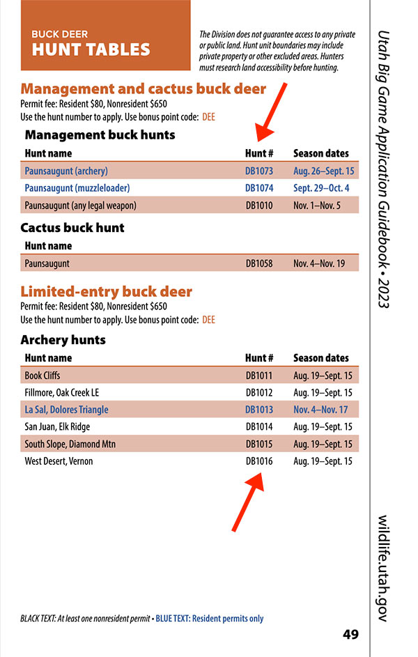
Hunt numbers are listed in tables like these in the Big Game Application Guidebook, p. 49.
Using the hunt number, search for information about a hunt in the Hunt Planner:
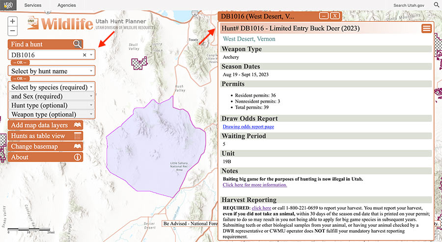
Type the hunt number in the "Select by hunt number" box. The hunt unit boundaries will be highlighted on the map, and a window with more information about the hunt will appear.
Q: What kind of information is provided for each hunt unit in the Hunt Planner?
A: The information provided in the Hunt Planner is broken out into several sections.
-
General hunt information: This includes the hunt name, allowable weapon type, season dates, harvest reporting requirements and number of permits allocated (if applicable).
Please be aware that some season dates (such as for big game) are established in the late winter, but permit numbers are not confirmed until late spring. Permit numbers may not always be available depending on the time of year, since those numbers are based upon up-to-date data from our biologists and approved by the board.
- Biologist information: This section is written by the area biologist and provides information about hunting that species in that area.
- Boundary information: This is information specific to the area and not necessarily the species being hunted. This section provides crucial information on the area such as campgrounds, road closures, access points, closed areas, land-ownership issues and wildlife management areas. This area is also regularly used to update hunters on fast-moving changes in an area such as wildfires, road closures or backcountry access improvements. This section also includes the legal written description of the boundary.
Q: Where can I find the hunt number on my permit?
A: All hunts are assigned a 6-digit letter/number combination. This number is printed in several places on any permit issued by the DWR:
You can then search for that number in the Hunt Planner to learn more about the hunt:
Q: How do I figure out all of the potential hunts I can apply for by species, weapon type, etc.?
A: With a few simple steps, you can view all hunts of a particular type — such as limited-entry buck deer — and see all the seasons, weapons and number of allocated permits statewide. To view summary tables of hunts, from the dropdowns (in the top left part of the screen) select a species, sex and hunt type. For example, to view all limited-entry buck deer hunts in Utah you would select:
- Select by species (required) → Deer
- and sex (required) → Buck
- Hunt type (optional) → Limited entry
- Weapon type (optional) → (You may also further filter to weapon type; select one or none)
Then, click Hunts as table view.
A table of all hunts will be displayed within those criteria (the following image shows just a partial list). Click on the hunt name/unit row to see the boundary and all the other information published about that hunt:
You can further filter each category, such as just hunts with "Book Cliffs" in the name:
Or, for example, all archery hunts:
Q: Where do I see how many permits are allocated for each unit?
A: Total permits allocated are published to the Hunt Planner within 10 business days of the numbers being approved by the Utah Wildlife Board. Please see the public meetings page on the DWR website for more information about dates of the public Regional Advisory Council and board meetings, and the subjects they will be taking action on. Once published, the total number of permits allocated appears in the information box for a given hunt:
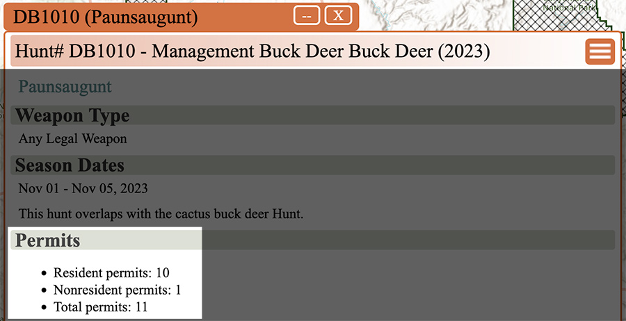
For this hunt in the Paunsaugunt unit, there are 11 total permits, including 10 for Utah residents and one for a nonresident.
Q: How can I view the drawing odds for a unit?
A: Drawing odds are not currently integrated into the Hunt Planner platform for each unit. To find out what the drawing odds are for a hunt unit, click on the "Drawing odds report page" hyperlink highlighted in the hunt description in the Hunt Planner. This sends you to a landing page on the DWR website with links to static reports of several previous years' draw results, which are viewable as PDFs.
Search tip: Use the "find" function in your web browser (press "Ctrl+F" on your keyboard, if you are using a laptop or desktop) to search for and jump to a hunt number in the PDF.
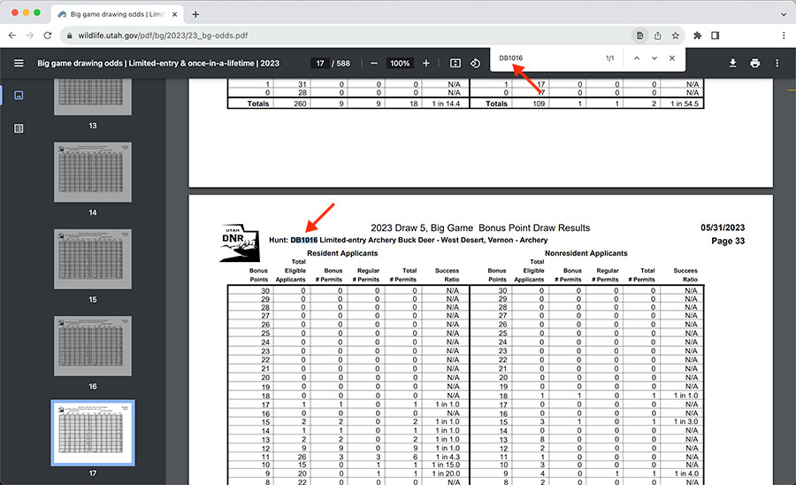
Drawing odds documents such as this one can be quite large, so you may need to search the document for a hunt number.
Q: Where do I find the boundaries for my hunt unit?
A: Hunt boundaries are published in the Hunt Planner for every established hunt. To find boundaries for a specific hunt, search for the hunt number printed on your permit, or browse to a hunt by scrolling in the "Hunt name" field. After you select the hunt and it loads, the boundary will be shown on the map; at the very bottom in the hunt information window, the legal written description is also provided for every hunt.
Q: How do I find which areas of a hunt unit are on private or public land?
A: The DWR provides a data layer that can be turned on or off in the Hunt Planner. This layer does not provide information on who owns specific property; it only designates public/private land. The DWR provides this as general information only in the Hunt Planner, and it is intended to help hunters get started on figuring out where to hunt.
To view the land-ownership layer, expand the search section titled "Add map data layers" and click on "Land ownership."
Important: The DWR does not and cannot provide specific information on land ownership. Land-ownership details (and some limited contact information to obtain written permission to hunt) can be obtained by visiting the county assessor's office associated with the hunt unit location.
Hunters are solely responsible for determining if the area they intend to hunt is public or private land. Hunters should obtain written permission to hunt private land before purchasing a permit.
Q: If an area is private property, how do I find the landowner's information to ask them for permission to hunt there?
A: You can contact the county assessor's office for the county where the private land is located. The DWR does not manage or keep track of land ownership.
Q: How do I figure out if an area I'm interested in hunting is on private land that's part of a Cooperative Wildlife Management Unit?
A: In the Hunt Planner, CWMU hunts can be located by selecting the CWMU by hunt type (species, sex, weapon type), and adding the CWMU map layer. Once the CWMUs in your search fields load, hover over or tap the crosshatched area of any CWMU and the boundary area name will pop up.
Keep in mind: If you draw a permit to hunt a CWMU, you must contact the CWMU operator to confirm the dates you'll be allowed to hunt within the legal CWMU hunting season framework; obtain a map of the CWMU showing access points and huntable areas; and follow the CWMU's rules, which may include restrictions on if and where preseason scouting, vehicle access or overnight camping are allowable. Learn more about CWMUs and how they operate here.
Q: How do I find public areas to go waterfowl hunting?
A: The Hunt Planner provides a data layer for all DWR-owned properties. To view wildlife management areas on the Hunt Planner, expand the "Add map data layers header and choose "Wildlife Management Areas." This will populate the map with all the WMAs we manage. Click on a boundary to learn more about it such as the activities allowed and seasonal closures.
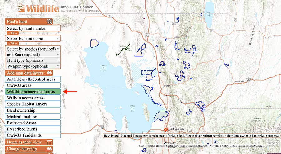
Also be sure to check the other data layers, such as Walk-in Access properties and restricted areas, in the area you wish to hunt.
Additionally, information is published in the Hunt Planner for the various goose and waterfowl zones and seasons:
If you have additional questions about using the Hunt Planner or a particular hunting area, please contact a DWR office near you for assistance.
Learn more
- Video: See Phil's presentation to the Utah Wildlife Board during the work session in April 2023, Hunt Planner demonstration (beginning at 5:52:37)
- How bonus and preference points work
- Blog post: Utah's big game bonus points and preference points system
- "Wild" podcast: Episode 41: Big game drawing
